Search

Eva Wallace

"The technology keeps moving forward, which makes it easier for the artists to tell their stories and paint the pictures they want" -George Lucas

Tag

digital

Past Present[ation] and future

With the combination of my last two posts and the usage of Emaze I created a presentation outlining the strategy plan to fulfil in order to reach the end goal of the data curation.

Found here: https://www.emaze.com/@AFZRWRCF/presentation-name

The end goal with the curation of this data is to keep the same excitement and enthusiasm expressed by the client in the discovery of this amazing information http://corklgbtarchive.com (Orla Egan)

The origin of this project is from the initial boxes discovered with Arthur Leahy. We want to keep this image, origin and heart. This is desired in instilling the same sense of excitement and exploration in curating the data into virtual boxes that separate to audio, video,text and images. Yet linked to the relevant data. This imagery can be seen at the end of the slide.

The next step in the process in under taking this task to manageable chunks to be slotted into the SCRUM plan and put into motion.

SCRUM-ptious

As mentioned in my last blog post SCRUM is a management method that stems from ‘agile’. Evernote notes

SCRUM is lightweight and perfect for clarity when a team work together in order to reach a common goal. It is flexible in the sense that is so fast paced that can easily be re adapted around the clients needs. In the case of the cork LGBT archives this method works very well as new content may be discovered as any point. http://corklgbtarchive.com

Here is an image of the SCRUM plan

This can be broken down to To do, doing and done. In assigning each person a colour per sticky note this allows each member to be able to clearly see the progression of the project. The transparency here keeps the flow of the project in manageable chunks with the relief at the end of saying ‘done’ to reduce pressure and increase productivity.


Mapping a house a very big house in the countryyy…

Openstreetmap

As part of Digital Humanities I used “openstreetmap”. This is a crowd sourcing project whereby the users contribute in mapping geographically,below is my experience.

Process:

  • Before beginning my work on the openstreetmap I first read the suggested material.(Found here: (http://learnosm.org/en/) . I found this resource useful as in reading the beginners guide I immediately found the purpose of the map is to aid others and improve their lives. I like how this in an initiative done in such a large international co-operation I find that it really highlights the power of technology today.
  • As instructed by the beginners guide I began with a small sketch map of my area using a key and understanding what are key landmarks and important information to include on the map.(Shown below is my map).
  • sketch map
  • To follow I used the search bar provided to find my locality and compared to my own sketch map.
  • Using the ID in browser editor I, to the best of my ability added in correct names for the “green” eg:Manhattan, included a local grotto, road, path, shops(ie:Smyths toys) etc. Here are two screen captures of some of the pieces that I contributed.1:Re-naming ,2:Outlining and naming.
  • manhattan naming pitch
  • I found the editor very user friendly as it’s drop down menus are very accurate and descriptive in what the user would like to fill in. eg:Grotto=Place of worship, Christian. However I found that some tags were lacking eg:Football pitch.

The implications of what I contributed:

  • My project was mapping my own locality which I found easy and I know is accurate as I know the area very well.
  • In contributing to the openstreetmap I have aided in the accurate mapping of my locality, with the inclusive feature I could see that I was sometimes even overwriting information that has been inputted 4 years ago.
  • In contrast to someone not from the area filling in incorrect information.
  • This information can now be globally used in order to eg: find a location more accurately. According to “Quora.com” and “arstechnica.com” openstreetmap is now being used by apple for the updated iphoto on the new iOS as opposed to Google maps. Therefore this work is also contributing to that international usage also.

What I learned from the experience :

  • From the experience of mapping my locality I found that I really enjoyed the process.
  • I also found how interesting it is to be involved in such a global task and will definitely contribute again in the open street mapping.From this I will look for other similar projects as I like the international co-operation,as I have stated and how powerful the interconnection is when harnessed in such a way.
  • I learned that the openstreetmap is much like open source in that it is accessible by all to be further improved. When I took a further look inspired by open street map I found “Github” (https://github.com/explore). To allow others to get involved in open source projects.
  • Furthermore, of course I’ve learned how to use a new digital tool and another usage for mapping that could later be used for other applications such as instagram.

How I feel I might be able to apply the spatial or the crowdsourced initiatives in my own work – now or in the future:

  • In terms of spatial, I will again use mapping as I learn and think very visually. A tool I would use for this would be “Xmind” that is mapping but not necessarily geographic.This would be for most tasks such as studying or working out an idea.
  • As I have previously stated this is also useful for other applications such as instagram (http://www.mapstagram.com/) allows the user to place their image on a world map. Producing a new method of visual presentation that is far more visually pleasing.
  • The spatial mapping as a tool in general would is extremely useful in data representation such as translating data to the new format eg(http://www.crimemapping.com/map.aspx) allows the user to see the latest crime data on the map. For my own work this shows how I can translate my data in the future to a map effectively.
  • In the future I do hope to participate in more crowd sourcing activities both to help others and to perhaps create my own project in the future with the request for help online by others like this. For example surveying and then mapping the collected data.
  • Right now,on a very small scale I ask visitors on my blog for interaction and commenting to make my work more of a group initiative. Also I will be writing for another blog soon as a guest blogger. Overall I feel that the open street mapping activity will affect my own work in the future as I really enjoyed this crowd sourced participation.

Geo-kaching$

Digital Humanities-review of a digital tool

Here is my review of a digital tool of the application supporting geocaching. I chose this tool as I wanted to utilize a lightweight tool that would cross the borders between digitization and reality. I feel that the geocaching tool achieves this as it allows the user to use GPS mapping technology, share experiences and connect about a real life treasure hunt, the tool is just that, a tool,not the entire activity and has a reinforced sensation of real life fulfillment upon completion(a cache is found). I liked this concept as I feel it is lighthearted and fun much like my wider project.

My tool

The digital tool that peaked my interest was “Geocaching”. I came across “Geocaching” from suggestions on Pinterest. “Geocaching” has become an international tool/game with the purpose of outdoor play with team-building, problem-solving and other outcomes. The tool I am reviewing is the geocaching app on iphone and android,more specifically to begin,the intro free version. My wider project would be explained by my wordpress  to examine the mind to a degree but attain an optimistic light hearted space. My aim here is to find a good crossing between the digital and the real world again as I have stated.

Website

For more information on the application it is reinforced with a website.I really liked the website and sound the interface really easy to use. The website is equipped with different media from text to video which I like. The videos explain that “Geocaching is an online adventure where you can use your GPS or your phone to track a nearby “cache” which can be anything using the GPS location after setting up a free account.The aim is then to find an object of whichever shape or size, sign the logbook or even trade “nic-naks”. I really like how the website gives a full explanation of the idea of this tool as it is different and is incorporating the digital world with the real life world and forcing exploration as opposed to just simply staring at a screen and find the concept of international digital co-operation very exciting. I feel that it is better that this information is explained furthermore on the website as opposed to the actual tool itself as I believe it would weigh down the tools lightweight image.

Articles

For further research on this tool I read online articles, all of which were very positive and encourage the reader to download the app and participate.The tool itself has a rating of 4 on the android official website.

Do these reviews indicate that the tool matches my research needs?

As I have stated my research needs here were simply to find a simple fun tool and was very pleased when I came across this integration. I find that the reviews do indicate that the application meets my needs of integration.

The future

In regards to a road map for this tool I feel like it has a good future ahead of it as currently has six million members in a world wide activity I think that this can only grow. I think that as photograph

logging has become such a huge area of the media currently that a development of perhaps a picture extension to the application solely for encouragement of the activity could also be a possibility.

The website has a forum also outlining updates currently and updates to come highlighting how quickly the development process is as well as having a blog again showing great integration with both people and the collaboration of digitization and reality/nature. The tool was born in 2000 and combined from geo meaning earth and cache from french meaning temporary storage,commonly used in computing makes the birth of the combined term perfect.

Originally the activity was restricted to those already expert in GPS usage such as hikers. A web developer called Jeremy Irish discovered this child of hiking and treasure hunting and decided to establish geocaching.com broadening the activity to the world to use. This has developed in fifteen years and is surely only going to further develop.Irish’s development shows the usage of open source in development and usability engineering.

With this tool, after signup you then have a profile,with this profile you can then log your own experiences and caches which can be exported to be shared with others as well as as i have said, participation in forums and blogs.

The application

Positives

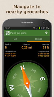
I think that the application/tool is very well done. I think the colour scheme is calming and pleasing to the eye and upon clicking the transitions are clean cut. The GPS built in tracks the user’s current location and immediately feeds the user nearby caches. We, the user are equipped with a compass to adventurously explore the surroundings appealing to the inner child in everyone as well as the tool being a lot more accessible and easier for the average person as opposed to an experienced hiker.

I enjoy how the application is clean and lightweight yet at the same time very detailed to even specify the sizing f the caches and allow caches to be logged on a personal profile.

Criticisms

Unlike actual GPS devices wifi is always needed which can prove to be difficult or even risky if the coverage is broken on an adventure.

This application can be quite limited and request a premium update of ten euro which is rather expensive in comparison to other apps in the app store, which disappointingly is requested after completion of approximately two caches.

The GPS is not entirely dependable the the calibration can be somewhat off,sadly.

The application does not allow users to visit other users profile which can be somewhat of a downfall.

Conclusion

In summation, I think that the concept of the tool sadly exceeded the abilities. It reached my needs of bridging a gap between digital and real life yet at the same time I encountered some difficulties,as did other users of the maps not being accurate enough and some desired modifications like the ability to view other peoples profiles. Overall out of five I would give this application a three.

Below attached is a link to my contribution of The geocaching application to the DIRT directory

http://dirtdirectory.org/resources/eva-wallace
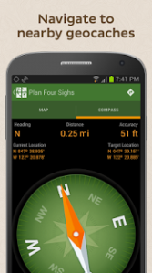
unnamed

At the euro,euro-peana

To keep things a little Digital Humanities again folks I’d like to mention a new tool we were introduced to in class called “Europeana” http://europeana.eu/portal/ .

This tool, as you can now see is used to view pieces of art,text,video-history in a webpage quite simply. Firstly I searched “Birth of the Venus” by Boticelli and the book of kells as I have previously studied these pieces in the past in great detail. I really love how several versions of the pieces are readily available as opposed to just a picture.

Secondly I found it to be quite unique how the webpage allows the user to easily progress between formats at the press of  button between text to video to 3D. I think that in availing from these formats gives the user a deeper perspective and the sensation of a hands on approach that could not be achieved in real life.

My mild criticism:(Before I explain how I like this tool I would just like to outline that the only drawback I found from the page was at times the loading period was quite long.)However I found the page user friendly and liked how it bridged between blogs and pinterest also.

As we have discussed in class-of course there is a downside in is this really how he artist intended their experience,through a screen? Yet at the same time I think that it allows the work to be shared vastly to the world as opposed to those who are lucky enough to get the opportunity to visit the pieces. As well as this, this digital representation allows the user to see the “nitty gritty” of the piece,how it’s made.

In summation in what I feel was most important from this tool it allows immortality of the pieces-untouchable from decay sitting cozily on a server. I found this idea reminiscent to the poem “Shall I compare thee” by Shakespeare (wow this is getting cheesy) in which he states: “But thy eternal summer shall not fade, Nor lose possession of that fair thou ow’st, Nor shall death brag thou wand’rest in his shade, When in eternal lines to Time thou grow’st. So long as men can breathe, or eyes can see, So long lives this, and this gives life to thee.” I find that this similarly encapsulates the infinite nature of the art when documented in this way.

Love is an open souurce!

Getting a bit digital humanities here..

Here to embed!

http://static.fsf.org/nosvn/FSF30-video/FSF_30_720p.webm

In a previous DH class we discussed the concept of open source. Open source is defined as “denoting software for which the original source code is made freely available and may be redistributed and modified”. I feel that this is an exciting and refreshing idea that most certainly be kept up and not locked down. With this, we as an internet community(granted we all get along for a little while) can grow at an extremely rapid rate evolving for the better. Of course there is drawbacks of open source software whether it be slower download times or updates that are not as up to scratch,if the “open source movement” is harnessed correctly it could vastly improve software. For example user interface created from people from every field-not just a sweaty coding mastermind with no other skill. I feel that with this software can be created collaboratively towards whats really needed,not just technically correct. Above to further explain I have embedded a video from “http://www.fsf.org/”. As always feel free to comment!

Have a nice day!:)

Eva x

Blog at WordPress.com.

Up ↑